As his bush plane circled the craggy peaks of the Alaska Range, the explorer Bradford Washburn peered down and had a burning thought.
Coursing down the southern slopes of Denali and Mount Silverthrone were the accumulated snows of thousands of winters, compacted under their own weight into colossal rivers of ice that filled the valleys for kilometres in every direction. At one particular spot in the white wilderness, Washburn noticed from above, all this glacial mass was somehow squeezing through a granite-walled corridor just over 1.6km wide.
Washburn became convinced, he wrote, that beneath the ice lay a secret: The corridor was deep. Deeper, perhaps, than any other gorge on the continent, and maybe even the planet.
That was 1937. Nearly 90 years later, a team of scientists set off into the windswept mountains to measure the glacier with snowmobiles and ice-penetrating radar. It wasn’t easy: The Great North does not surrender its mysteries readily. The researchers almost didn’t think they’d found anything of interest.
Now, thanks to some clever analysis, and a bit of luck, they have put forth the most conclusive evidence yet that Washburn was right — that the area could be the deepest gorge in North America.
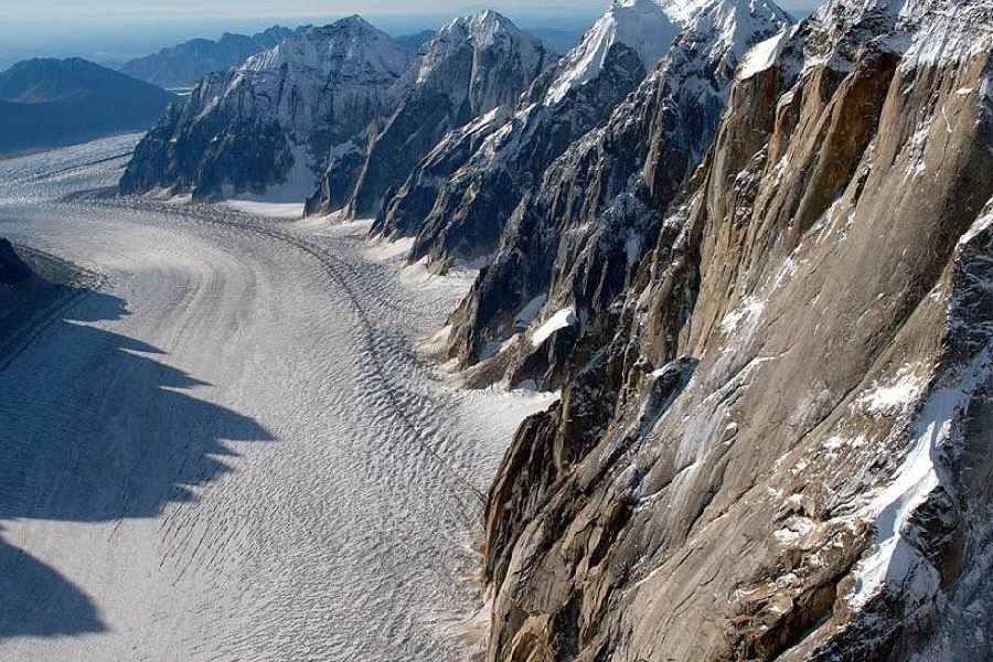
Even by the standards of Denali National Park and Preserve, where the massive landscapes have enthralled alpinists for generations, the gorge and glacier that captivated Washburn stand apart.
The ice of Ruth Glacier first gathers in a vast field rimmed by towering granite ridges, the names of which — Moose’s Tooth, Bear’s Tooth, Eye Tooth — give some sense of their sheer, sharp verticality. The glacier then winds through a rift, known as the Great Gorge, where the nearly 1.5km-high cliff walls remind you how much of the place lies unseen and underfoot.
“Not only do you have this unbelievable landscape above you, but you have an equally unbelievable landscape buried in ice underneath you,” said Martin Truffer, a glaciologist at the University of Alaska Fairbanks. “That’s something I’ll never quite get over.”
As the planet warms, Ruth Glacier is thinning at a pace of more than three feet a year, scientists have estimated by using airborne laser surveys. In Alaska, some glaciers are changing so quickly, said Chris Larsen, a geophysicist at Fairbanks, that he can no longer remember what they looked like 10 years ago. “It’s worse than watching a kid grow up,” Dr Larsen said.
The first time scientists set out to test Washburn’s hunch and find the Great Gorge’s bottom was in 1991. They were quickly thwarted: The gorge is so deep and narrow that their radar echoes ended up bouncing off the sides, sending back a jumble of noise.
A year later, the researchers tried again, this time with a more combustible approach. Larsen, fresh out of college, was a technician on the expedition. The scientists drilled holes in the ice, filled them with explosives and triggered small blasts. They used seismic instruments to measure the resulting acoustic waves.
They managed to get some readings of the gorge’s shape and depth, which they estimated to be almost 9,000ft. That’s deeper than both the Grand Canyon and Hells Canyon, North America’s deepest river-carved gorge, which sits on the Idaho-Oregon border. But over time, scientists came to question the findings, especially as satellite images allowed researchers to map glaciers digitally. By 2019, Jack Holt, a geologist at the University of Arizona, wanted to take another crack at measuring Ruth Glacier from the ground.
Holt started organising an expedition with the support of Robert Sheldon, a businessman whose father, Don, had been a famed Alaska bush pilot. Decades earlier, Don Sheldon had flown with Bradford Washburn to map Denali, then known as Mount McKinley, and the surrounding peaks. Washburn’s fascination with the Great Gorge had captivated Robert Sheldon as well.
“Let’s get this done once and for all,” Sheldon remembered thinking, to honour “the legacy that both my dad and Brad left behind”.
In spring 2022, Holt landed in the mountains with Truffer and two other researchers, Brandon Tober and Michael Christoffersen. They brought with them a specially designed radar rig, and for about a week they towed it behind a snowmobile across the glacier’s snowy expanse, back and forth, back and forth, as it sent 1,000 radio waves per second into the ice below.
At first, the scientists were pleased with the echoes coming back. “Just looking at the data as we acquired it, I thought this was really working well,” Truffer said. Later, though, when they examined the numbers more closely, they realised they had a problem.
Their soundings of the glacier above the Great Gorge had yielded good measurements of its thickness there. But their data from within the gorge contained too much noisy clutter, the same problem that had foiled the 1991 expedition.
Then, late last year, a breakthrough: The scientists realised that a Nasa mission had made airborne measurements of the ice farther down Ruth Glacier, below where it empties out of the gorge. By combining this data with their readings from higher up the glacier, and applying what they knew about how quickly the glacier was flowing, the researchers could infer the rough dimensions of the ice, and hence the gorge, in between.
Their final estimate of the Great Gorge’s depth, from the summit of Moose’s Tooth to bedrock: about 8,085ft. Hells Canyon, by comparison, plunges down 7,913ft. (Several valleys in the Himalayas and the Andes are deeper still.) The team’s findings were published in the Journal of Glaciology on Wednesday.
New York Times News Service