Cyclone Dana that made a landfall close to the Bhitarkanika National Park in Odisha between Thursday midnight and Friday morning did not impact West Bengal, including Kolkata, the way it was earlier predicted. However, it brought copious amount of rain on Friday, post-landfall.
This correspondent spoke to several climate and weather experts to decode the reasons.
Why Bengal was largely spared before and during Dana landfall

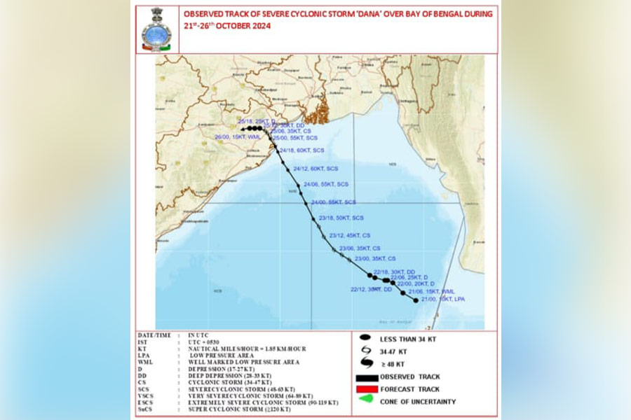
Observed track of Dana over Bay of Bengal during October 21 to 26, 2024 India Meteorological Department, India
Experts point out that a range of reasons had combined to save West Bengal from significant Dana damage late on Thursday night till the early hours of Friday.
Former IMD director-general K.J. Ramesh pointed out that the landfall point had shifted marginally towards the west compared to initial predictions. “West Bengal was less affected than predicted earlier, as the cyclonic system slightly veered towards Odisha away from West Bengal in the final stages, closer to Paradip,” opined Ramesh.
IMD scientist and cyclone specialist Ananda Das pointed out that the protracted landfall period saved West Bengal from much effect than anticipated in the initial part of the prediction.
“The landfall started around 1.30am on Friday and continued till 8.30am; a much longer duration than normally observed. Actually, the landfall was initiated around Dhamra port and then, instead of moving north-westwards as we had thought, it continued northwards along the coast — part of the cyclone system over the land and the rest over sea. Such a state continued till 5.30am and in the process, lost strength on its way,” explained Biswas.
The scientist explained that owing to this pathway, the impact was limited mostly to Odisha. “We earlier thought that an anti-cyclone generated in the area would push it towards the north-west but that did not happen,” said Das.
Ramesh further explained that a steering wind might have pushed the cyclone away from West Bengal.
Kolkata, located around 250km away from the landfall point and close to the edge of the cyclonic system, hardly felt the impact of the cyclone apart from some drizzle during the night though the coastal areas of West Bengal, including the Sunderbans, received rain last Thursday.
“There has been severe rain throughout Friday and the paddy on the ground has been damaged,” complained a farmer, Shankar Ari.
Incessant rain followed landfall in Bengal
When it seemed that Dana had completely spared West Bengal, came the rain post-landfall. Major part of the south Bengal, including Kolkata, received widespread rain, and got inundated, on Friday.
An IMD bulletin at 10am on Saturday reported more than 100mm rain precipitation occurred over 24 hours starting from 8.30am on Thursday in places like Kolkata (133mm), Barrackpore, Sagar, Howrah, Haldia, Midnapore, Diamond Harbour and Bardhaman.
IMD expert Das attributed the disintegration of the Dana cyclonic clouds to the rainfall.
“While the lower level cloud of Dana, till 3.1km above the earth’s surface, remained confined within Odisha, the upper level ‘overflow’ clouds under the influence of westerly winds spread all over south West Bengal and triggered widespread rain on Friday,” said Das.
According to the bulletin, the cyclone has dissipated into a ‘well-marked low pressure area’ in the morning hours of October 26.
“Not much rain, related to Dana, is expected in West Bengal from Saturday, as it has not only relegated to a well-marked low pressure area. Moreover, it has veered towards Jharkhand,” stated the IMD official.


