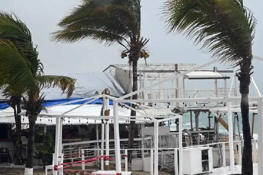
Hurricane Idalia gained fury on Tuesday as it crawled toward Florida's Gulf Coast, forcing mass evacuations in low-lying areas expected to be swamped when the powerful storm, forecast to reach Category 4 intensity, strikes on Wednesday morning.
Idalia was generating maximum sustained winds of 110 miles per hour (177 kph) by late Tuesday night - at the upper end of Category 2 - and its force will ratchet higher before it slams ashore, the Miami-based National Hurricane Center (NHC) projected.
By that time the storm was forecast to reach "an extremely dangerous Category 4 intensity" - with maximum sustained winds of at least 130 mph (209 kph) - on the five-step Saffir-Simpson wind scale, the NHC reported.
The hurricane was upgraded on Tuesday evening to a Category 2 after its top wind speeds surpassed 95 mph (153 kph), feeding on the warm, open waters of the Gulf of Mexico. Any storm designated Category 3 or higher is classified as a major hurricane.
Idalia's most dangerous feature, however, appeared to be the powerful surge of wind-driven seawater it is expected to deliver to barrier islands and other low-lying areas along the coast.
Florida Governor Ron DeSantis, who is seeking the Republican presidential nomination next year, urged residents in vulnerable communities to heed orders to move to higher ground, warning that the storm surge could cause life-threatening floods.
"They're expecting some fatalities, so I don't want to be one of them," said Rene Hoffman, 62, of Steinhatchee, Florida, a coastal town in the area where Idalia is expected to make landfall. She owns a food stand that she lashed to her husband's pickup truck to keep it from washing or blowing away.
"This is scary, you know, to think that water could come this high," she said as she gathered her prescription medications and prepared to leave her home. "We've never had water up here before."
The NHC said Idalia's center would likely hit Florida's coastline somewhere in the Big Bend region, where the state's northern panhandle curves into the Gulf side of the Florida Peninsula, roughly bounded by the inland cities of Gainesville and Tallahassee, the state capital.
Sparsely populated compared with the Tampa-St. Petersburg area to the south, the Big Bend features a marshy coast, threaded with freshwater springs and rivers, and a cluster of small offshore islands forming Cedar Key, a historic fishing village devastated in 1896 by a hurricane's storm surge.
Most of Florida's 21 million residents, along with many in Georgia and South Carolina, were under hurricane, tropical storm and storm surge warnings and advisories. State emergency declarations were issued in Florida, Georgia and South Carolina.
At the White House, U.S. President Biden said he and DeSantis were "in constant contact," adding that he had assured the governor federal disaster assistance would remain in place for as "long as it takes, and we’ll make sure they have everything they need.”
Gulf energy producers were taking precautions as well. U.S. oil company Chevron evacuated staff from three oil production platforms, while Kinder Morgan planned to shut a petroleum pipeline.
Idalia-related disruptions extended to Florida's Atlantic coast at Cape Canaveral, where the Tuesday launch of a rocket carrying a U.S. Space Force intelligence satellite was delayed indefinitely due to the hurricane.
Idalia grew from a tropical storm into a hurricane early on Tuesday, a day after passing west of Cuba, where it damaged homes and flooded villages.
By Tuesday evening, the storm was churning about 125 miles (201 km) west of Tampa as it crept closer to shore.
Idalia is in line to become the fourth major hurricane to strike Florida over the past seven years, following Irma in 2017, Michael in 2018 and Ian, which peaked at Category 5, last September.
Up to 15 feet of storm surge
In Sarasota - a city hard-hit by Ian last year - Milton Bontrager's home was boarded and stocked with food, water and a generator.
"I don't panic, I prepare," said Bontrager, 40, who runs six charter fishing boats in Venice along the Gulf Coast near Tampa.
He stopped taking customers out days ago so he could secure the boats. His biggest craft is tied down to a floating dock with 16 lines and equipped with battery-powered pumps that turn on automatically if the boat starts taking on water.
Florida's Gulf Coast along with southeastern Georgia and eastern portions of North and South Carolina could face torrential rains of 4 to 8 inches (10 to 20 cm) through Thursday, with isolated areas seeing as much as 12 inches (30 cm), the hurricane center warned.
Surge warnings were posted for hundreds of miles of shoreline, from Sarasota to the sport fishing haven of Indian Pass at the western end of Apalachicola Bay. In some areas, the surge of water could rise 10 to 15 feet (3.0 to 4.6 m), the NHC said.
"The No. 1 killer in all of these storms is water," Deanne Criswell, the Federal Emergency Management Agency's administrator, said on CNN.
More than 40 school districts in Florida canceled classes, DeSantis said. Tampa International Airport closed to commercial operations with plans to reopen on Thursday.
About 5,500 National Guard members were mobilized, while 30,000 to 40,000 electricity workers were placed on standby. The state has set aside 1.1 million gallons of gasoline to address any interruptions to fuel supplies, DeSantis said.
Brush with Cuba
As Floridians braced for Idalia's arrival, Cubans were grappling with the aftermath of the storm, which lingered for hours on Monday near the western end of the Caribbean island nation, toppling trees and flooding coastal villages.
In Pinar del Rio, an area known for producing the tobacco used to make some of the world's finest cigars, 60% of the province was without power. Tens of thousands of people were evacuated.


