A spell of intense rainfall, which saw over 110mm of rain in just one hour in at least one pocket, struck Calcutta on Wednesday afternoon and led to waterlogging across the city.
The heavy spell lasted for around two hours, between 1pm and 3pm. The showers flooded busy roads and stalled traffic.
The rain, preceded by a cool breeze, started around 1pm. The intensity went up fast and the rain was blinding in most parts. In just an hour, between 2pm and 3pm, Ballygunge received 114mm of rain, according to figures obtained from the booster pumping stations of the Kolkata Municipal Corporation.
To put things in perspective, 60mm of rain in 24 hours qualifies as “heavy” in Met parlance.
The Met office recorded 72mm of rain in Alipore — officially, between 8.30am and 8.30pm, but in reality in just two hours in the afternoon.
The civic body’s report showed that Topsia got 72mm and Mominpore 51mm of rain between 1pm and 3pm. Maniktala and parts of EM Bypass near Dhapa got 49mm each, in roughly the same time.
In terms of intensity, Wednesday’s rain was the strongest so far this season. The Alipore Met office had received around 70mm of rain in 24 hours, between the evening of May 6 and 7.
On Wednesday, the result was for everyone to see. Around 3pm, two-wheelers parked on several city roads were almost half-submerged in water, as were cars.
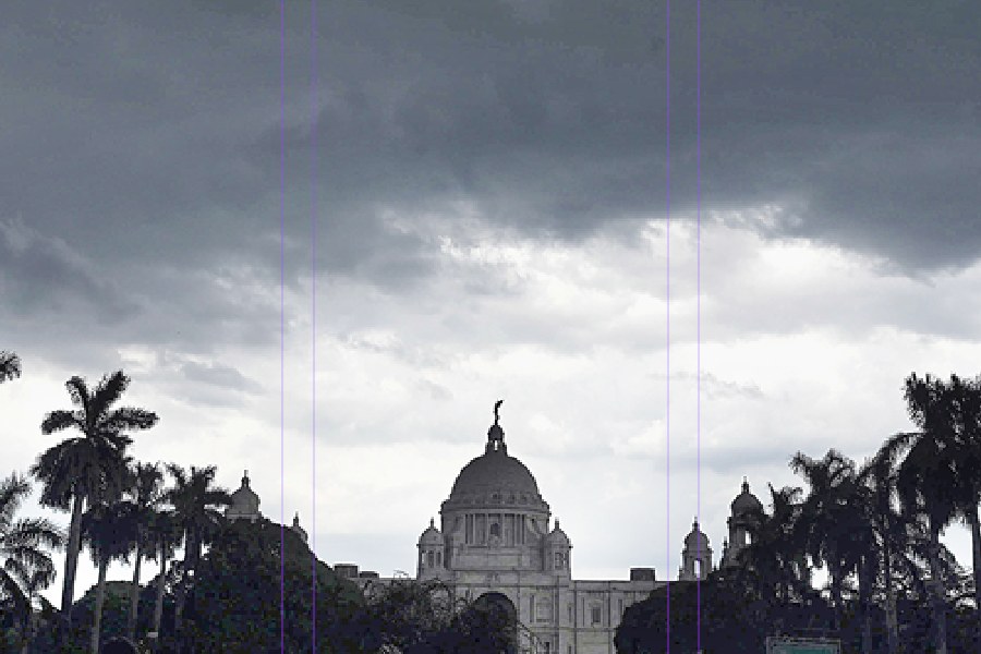
The morning was sunny, hot and sweaty. But the conditions changed swiftly. Around 1.25pm, the sky over the Maidan became so dark that it looked ominous.
The Met forecast had predicted rain on Wednesday but the intensity of the showers caught Calcuttans off guard.
Two systems were at play to trigger the rain, said a Met official. Strong moisture incursion from the Bay of Bengal played the perfect catalyst.
“The cyclonic circulation over east Bangladesh and neighbourhood now lies over Bangladesh and adjoining Bengal between 3.1km and 5.8km above mean sea level. A trough runs from northwest Rajasthan to Bangladesh across north Madhya Pradesh, south Uttar Pradesh, Jharkhand and West Bengal at 0.9km above mean sea level,” said a Met bulletin.
The twin systems fed on the high moisture content to form strong cumulonimbus, or rain-bearing, clouds.
Districts such as Birbhum, Howrah and North 24-Parganas also received sharp spells of rain.
A set of clouds took over the entire length and breadth of Calcutta, said the Met official.
“Rain is also caused by passing clouds. Strong winds often push the clouds away from a place. But today (on Wednesday), the clouds became stagnant. They literally emptied themselves on the city,” said the official.
Eye on the Bay
Rain is not entirely ruled out in Calcutta on Thursday and Friday but there is little chance of a repeat of Wednesday, said the Met official. The rain will be caused by a new weather system, said officials.
“Uniform and widespread rain is likely from Saturday evening,” he said.
The showers will most likely be triggered by a much stronger system that took shape in the deep sea on Wednesday.
“A low-pressure area has formed over southwest Bay of Bengal and adjoining west-central Bay of Bengal off north Tamil Nadu-South Andhra Pradesh coasts.... It is very likely to move northeastwards and concentrate into a depression over central parts of Bay of Bengal by the morning of May 24 (Friday),” said a Met bulletin.
“It is likely to move further northeastwards and intensify further and reach northeast and adjoining northwest Bay of Bengal by the evening of May 25 (Saturday).”
A depression intensifies into a deep depression and then a cyclone. The Met bulletin, however, made no mention of either.
“The system is still close to 1,000km away from the Bengal coast. We should get a clearer picture by Thursday,” said the Met official.
The north Bay of Bengal is closer to the Bengal coast.
The Met bulletin has predicted heavy rain in the coastal districts of south Bengal — East Midnapore, North 24-Parganas and South 24-Parganas — on Saturday and Sunday.
If the system does intensify into a cyclone, it will be called Remal, a name given by Oman. The last cyclone on the Bay, Michaung, named by Myanmar, landed in Andhra Pradesh on December 5. It wreaked havoc in Tamil Nadu and Andhra Pradesh.
Post-landfall, a remnant of the storm had caused formidable rain in Calcutta.