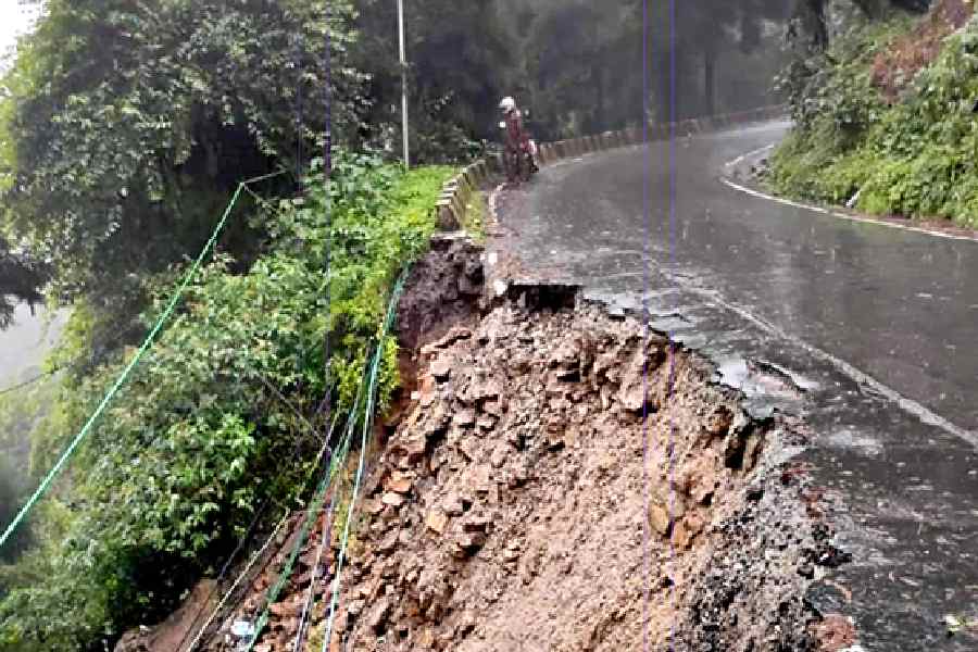
Experts warn that large-scale development projects in the sensitive eastern Himalayan region are jeopardising crucial road connectivity to the China border.
National Highway 10, a vital link for Sikkim and Kalimpong and more importantly an important link to the Indo-China border, is particularly at risk, according to soil scientist Dr Nirmalya Chatterjee.
Dr Chatterjee, who has a doctorate from Washington State University and has worked in the Sikkim-Darjeeling region, said: "From a technical soil-physics perspective, the fate of NH 10 is sealed. It will never be the same as it was before the dams were built.”
The 78.58km highway connecting Rangpo on the Bengal-Sikkim border to mainland India runs along the Teesta river for a stretch of about 52km. It is also along this stretch that the 132mw Teesta Low Dam-III and the 160mw Teesta Low Dam-IV have come up between 2013 and 2016 at a cumulative estimated cost of around ₹3,200 crore. This is also the most vulnerable stretch of the highway.
Experts said that long reservoirs created by these dams have resulted in deep waters of up to 25mt depth in the valley bottom where previously white-water rapids flowed. “The tremendous pressures of the water column help in pushing the water into the foot slopes of the hills forming the valley. This changes the character of the soil,” said Chatterjee.
“This had led to the entire stretch of soil layers at the base of the hillslopes and valley bottom between Kalijhora and Tribeni — the endpoints in the 25km ‘reservoir’ stretch, to be saturated with water,” he added.
This monsoon, the highway has caved in repeatedly forcing authorities to further cut the hill slopes to make space for a new road. “Road cuts of lesser steepness require more earthwork and thus both designers and contractors are loath to do this due to costs but less steep road cuts are stabler because they are less likely to slide when rain saturates and changes the mass of the soil,” said Chatterjee.
Dr Subir Sarkar, the former head of the geography department at North Bengal University, said: “For politicians, mega companies and even bureaucracy projects have to be big as these attract attention. In fragile areas, the load-carrying capacity should be the major criterion for development. There has to be a limit on the scale of development."
Vimal Khawash, professor at the Special Centre for the Study of North East India, Jawaharlal Nehru University, Delhi, said the geologically fragile Himalayas right till Meghalaya needs special attention.


