The Sikkim science and technology department has conducted a two-week long scientific expedition of the East Rathong glacier and three glacial lakes in the Gyalshing district of the mountain state.
The expedition was carried out to assess the risk of a potential glacial lake outburst flood (GLOF) on the waterbodies and the status of the glacier.
“The expedition was conducted from June 22 to July 4 as a part of the department’s ongoing study of glacier dynamics and assessment of potential GLOF risks. In the state, 19 potentially vulnerable glacial lakes have been identified so far and they include the three lakes where the study was conducted,” said a source in the department.
The initiative, he said, was taken after last year’s flash flood that had devastated the state on October 4. The GLOF on the South Lhonak Lake, which is in the Mangan district of Sikkim, triggered the deluge.
The study, officials of the department said, will help in drafting policies and strategies to mitigate risks during natural disasters.
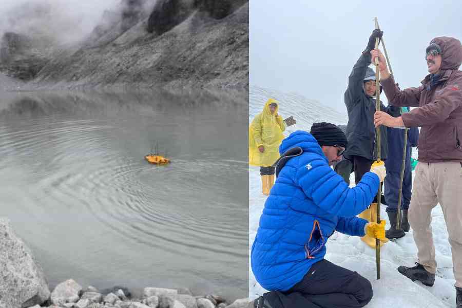
Last month, a team of scientists and researchers of the department reached Yuksom, the last village in Gyalshing in west Sikkim which is accessible by car. From there, they trekked for three days to reach the East Rathong glacier which is located at an elevation of 4,600 metres to 6,700 metres above the sea level near the Khangchendzonga National Park.
The glacier is also the source of the Rangit, a river which flows downstream into Bengal and meets the Teesta at Triveni in Kalimpong district.
The team, sources said, was divided into two groups. One group conducted a bathymetric study of the Tikip La Lake, Bhaley Pokhari and the Rathong Lake using an unmanned survey vehicle (USV).
The bathymetric study is a hydrographic or water-based survey to map the depths and shapes of the underwater terrain of any waterbody.
During the surveys of the three glacial lakes, the group made some significant scientific findings, said a source.
“The Tikip La Lake was found to have a maximum depth of 55 metres and lacks a defined open outlet, although its water appears downstream in the valley. The Bhaley Pokhari and Rathong Lake were found to have maximum depths of 42 metres and 25.4 metres, respectively, and both have clear-cut outlets. An assessment of the water volume of these lakes will also be carried out,” the source said.
The other group focussed on the study of the glacier.
“The experts monitored the velocity and vertical retreat of the glacier. They also studied the glacio-hydrology of glacier meltwater streams, and conducted a DGPS survey,” the source added.
The DGPS survey or Differential Global Positioning System survey is an enhancement of the GPS survey and provides a more accurate location of any place, which in this case, is the glacier and its surroundings.
The team also carried out repairs at an automatic weather station that was installed at the glacier and added instruments to upgrade the station.
“The data which they have collected during the expedition will be collated and experts will be engaged to study the same. The experts will come up with recommendations which in turn can reduce the risk during natural disasters, especially GLOFs,” an official said.