Telegraph picture
How long will the rain continue in Calcutta?
Intense showers are expected in the city on Saturday and Sunday. The showers are likely to start on Friday afternoon and there could be some showers on Monday as well, said Das. The Calcutta Municipal Corporation has asked all pumping stations to be on high alert.
Apart from Calcutta, which districts are likely to be affected?
East Midnapore, North and South 24-Parganas and pockets of Howrah, Hooghly and Nadia are likely to be affected. District officials and police in East Midnapore are taking precautions to mitigate the effects of the storm. “Digha is on yellow alert right now. Tourists have been cautioned,” said an official.
How is Bulbul likely to be different from Aila and Fani?
Aila (2009) had struck the Sunderbans at 110kmph and its maximum speed was 103kmph when it was blowing through the city. Aila had made landfall in Bengal and tall waves had wrecked havoc along the coast. In May this year, Fani had made landfall near Puri. Under its impact, the maximum wind speed in Calcutta was to be 100kmph. But it fizzled out when it passed over the city.
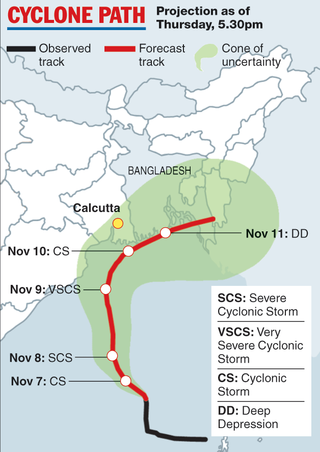
Heavy rain is expected in Calcutta on Saturday and Sunday as cyclone Bulbul advances towards the Bangladesh coast. Bulbul is likely to intensify into a very severe cyclonic storm as it moves over the sea but is expected to lose some steam by the time it makes landfall in Bangladesh and the Indian Sunderbans around Sunday afternoon, the Met office has said. A Metro primer on Bulbul
Why Bulbul?
The storm has been named by Pakistan. Bulbul is the name of a bird species. In 2000, India, Bangladesh, Pakistan Maldives, Myanmar, Oman, Sri Lanka and Thailand had come together to assign names to tropical cyclones originating over the Bay of Bengal and the Arabian Sea. The storm before Bulbul was named Maha by Oman. The one after this will be called Pawan, named bySri Lanka.
Where is the storm?
Bulbul was over the west-central Bay of Bengal on Thursday afternoon, 750km southwest of Calcutta. It was moving north-west but was expected to turn north-east towards Bangladesh.
When is it likely to be close to Calcutta and what will be its impact?
Bulbul is likely to hit the Bangladesh coast and a part of the Indian Sunderbans, around 150km from Calcutta, said G.K. Das, director, India Meteorological Department, Calcutta. Light rain is likely to start in Calcutta in the second half of Friday. The city is expected to get heavy rain (60-199mm over 24 hours) on Saturday and Sunday. The showers are likely to be accompanied by winds blowing at 20 to 30kmph. The winds could start blowing in the second half of Friday.
How strong will Bulbul be when it skirts Calcutta?
It is expected to intensify into a very severe cyclonic storm by the early hours of Saturday, generating wind speeds of up to 120kmph. But it is tipped to lose steam and turn into a severe cyclonic storm by Saturday night and remain so when it hits the Bangladesh coast on Sunday noon, with a wind speed of 90-100kmph. After landfall, it will lose more steam and turn into a cyclonic storm and then a deep depression. In Calcutta, the wind speed is likely to be between 20 and 30kmph, said an official.


