An expanding road network in Uttarakhand has left human settlements, bridges and roads along the Alaknanda and Bhagirathi river valleys more vulnerable to falling rocks and soil, triggered by rain, scientists have cautioned.
A major component of this road expansion is a widened, 889km stretch of the Char Dham road that provides round-the-year connectivity to the pilgrimage sites of Yamunotri, Gangotri, Kedarnath and Badrinath.
Anecdotal evidence has over the years suggested that roads and other infrastructure in the central Himalayan region of Uttarakhand are not designed to withstand the forces and speeds at which rocks, soil and slurry might hurtle down mountain slopes.
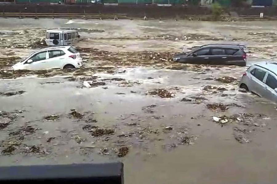
Now, the first study to quantify debris flow behaviour in the area has estimated that the debris pressure could reach up to 3,000 kilopascals, or over 10 times the air pressure in car tyres. And the debris rolling down mountainsides is likely to hit infrastructure at speeds between 15 to 20 metres per second (54-72km per hour).
The additional road network has contributed to an increase in concave-shaped sections of the slope topography. Enhanced concavity can amplify the pressure and speed of debris flow, the researchers said. The increased road network may thus lead to more debris flow events.
"The big question is: will human settlements and other infrastructure be able to tolerate such intense pressures and high speeds? In many cases, it would appear quite unlikely," said Vipin Kumar, professor and the head of the geology department at Doon University in Dehradun, who led the study.
Kumar and his collaborators in other academic institutions took into account geological and terrain features and historical rainfall records over the past 20 years to run computer simulations of debris flow at seven sites along the Alaknanda, Bhagirathi, Mandakini, Kali and Yamuna river valleys.
Their area of study falls along what scientists call the Main Central Thrust (MCT), a major geological fault line that runs along the Himalayas and plays a key role in shaping the mountains. The mountain along the MCT poses a barrier to monsoon winds and the area is therefore a high-rainfall region.
The researchers performed over 700 simulations to estimate the pressure and speed of debris flow at each of the seven locations.
Their results, just published in the Bulletin of Engineering Geology and the Environment, show that the pressures could range from 300 kilopascals to 3,000 kilopascals at three locations — near Sarnaul and Bhatwari in Uttarkashi and Nachani in Pithoragarh. The debris flow speeds predicted at these sites can reach up to 20 metres per second.
"These are extreme values and could cause damage to infrastructure," Kumar said.
The researchers also evaluated the road network in the area and found 939km of new roads between 2010 and 2020.
This increased road network density zone overlaps with high-landslide-susceptibility zones and most of the debris flow locations covered in the new study. The dense road network is also located in the high-rainfall zone that has experienced increasing rainfall between 2000 and 2020, the researchers said.
The other study collaborators are Yaspal Sundriyal from Doon University, Neha Chauhan and Sameeksha Kaushik from Garhwal University, Srikrishna Siva Subramanian from IIT Roorkee, Raquel Melo from the University of Lisbon, and Naresh Rana from the University of Delhi.
Some scientists and environmental groups had earlier criticised the way the Char Dham road-widening project had been implemented.
A high-powered committee, set up by the Union environment ministry under the Supreme Court’s directions to find ways to minimise its environmental impact and other consequences, had said the project had "damaged the Himalayan ecosystem due to unscientific and unplanned execution".
The committee had in a report submitted in July 2020 expressed concern that the project had cut hills without prior slope vulnerability analysis and without adequate slope protection measures, enhancing the risk of landslides.