Cyclone Remal missed the Indian coast by a whisker and landed close to a small forested Bangladeshi island called Mathar Dwip around midnight on Sunday, southwest of Mongla port city in the Khulna division, according to IMD sources.
The landfall point, as per crow fly estimate, was around 20km from the Indian border falling within the Indian Sunderbans. Seven people died in various parts of West Bengal because of Cyclone Remal.
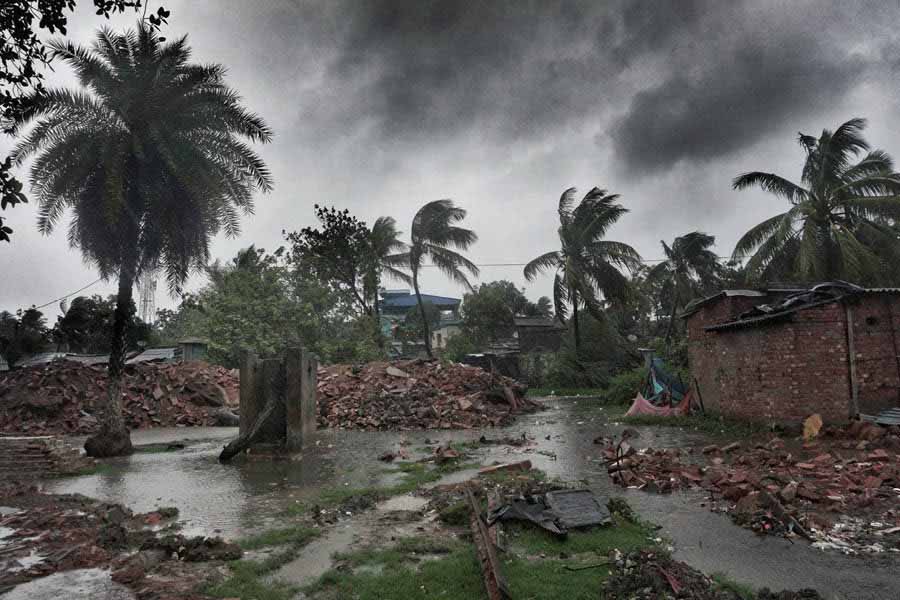
Kolkata escaped with not so major skirmishes, with rainfall and strong winds largely starting late on Sunday evening and continuing in spells through the night and most of Monday, mainly after the landfall by the wagging tail of Remal.

A 70-foot chimney from an abandoned factory of Bengal Immunity Limited at Baranagar on the northern fringes of Kolkata collapsed on cars parked within the adjacent compound of St James Church My Kolkata
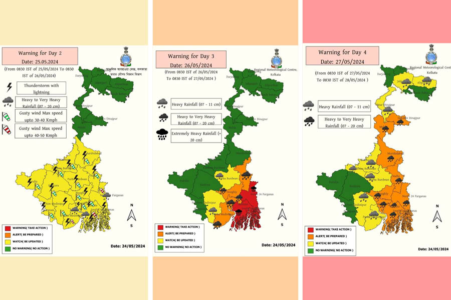
Under the impact, strong winds and rainfall close to 260mm within 24 hours continued till Monday evening as the cyclone system slowed down after the landfall; according to IMD sources. Close to 500 pumps operated to drain out water from Kolkata. The northern fringes of the city, as recorded in Dum Dum, received the strongest wind in the city at 91km per hour.
IMD pointed out early Monday morning that Canning, the West Bengal city where ironically the cyclone was coined, was hardly 70km away from the cyclone’s eye when it landed.
According to sources, nine persons died in both Bengal as a result of the cyclone so far, while close to 10 million were evacuated to rescue shelters on either side of the border, including nearly 1.5 lakh in West Bengal.
The point of landfall, alongside the timing, has made the Remal impact much less on ground compared to impacts triggered by Amphan or Yaas on the Indian Sunderbans, despite the region being struck by the combination of copious amount of rain and strong winds since Sunday morning that continued till Monday evening. Sources in the forest department confirmed that, so far, not much impact has been found within the forest area.
In Bangladesh, barely
Though few weather sites claimed that the landfall was within Indian land, IMD officials pointed out based on their radar-based analysis, coupled with on-ground monitoring shared by Bangladesh Meteorological Department that the landfall happened at a location with latitude-longitude 21.75 and 89.2 that gets zeroed down to a point just north of Mathar Dwip island in Khulna division of Bangladesh.
As the Sunday evening wore on, Remal came perilously close to the Indian coast though the landfall, which was initiated late Sunday evening and continued till early Monday morning, had landfall around 20km away from Indian Sunderbans, as per crow fly estimate.
The hourly bulletin number 9, issued by IMD around 3am on Monday, pointed out that “Remal … crossed the Bangladesh and adjoining West Bengal close to southwest of Mongla near latitude 21.75°N and longitude 89.2°E between 2230 hrs IST of May 26 to 0030 hrs IST of May 27, 2024 as a severe cyclonic storm with wind speed of 110 to 120kmph gusting to 135kmph”.

However, the expert admitted that Remal’s coverage area, a diameter of about 350 km, included a large part of West Bengal particularly coastal Bengal. “West Bengal actually received more rainfall though the wind was stronger on the Bangladesh side” added the expert.
“The cyclone impact is still there, with high rainfall and strong wind affecting the region, and expects to continue till today evening as the system has slowed down after landfall” explained a senior IMD official from Alipore, Kolkata at Monday noon; explaining why it has been still raining in Kolkata and elsewhere.
Embankments overtopped but not breached
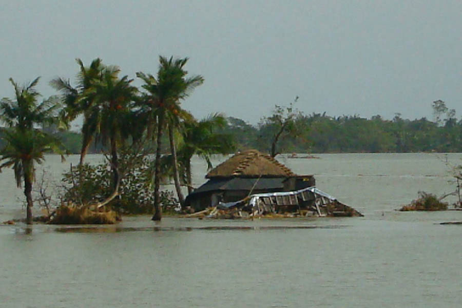
Within Sunderbans, Gosaba block, closest to the point of landfall that was barely 20km away from the border, was most affected with Kumirmari, the last human habited island closest to Bangladesh landfall point, suffering most within Gosaba block due to impact of the cyclone, confirmed state government officials.
“Gosaba is definitely most affected within Sunderbans; while Kumirmari island was most affected within Gosaba,” said a senior irrigation official.
“Though we did not have any major embankment breach but there were several cases of overtopping of water in Sunderbans with 67 such overtopping happened only in Gosaba,” said the official, claiming emergency patchwork, using machinery and manpower, in weak embankment areas, just prior to Remal strike, paid dividends.
Overtopping was also reported from various places in Sagar, Namkhana, Patharpratima, Kultali, Sandeshkhali and Hingalganj.
Local residents, in many areas, however, worked round the clock to strengthen the weak embankments in several places of Sunderbans.
“We have been barely saved as the Raimangal embankment did not breach as we feared;” said Debasish Mandal, the deputy pradhan (deputy head) of Kumirmari panchayat, sharing that many were evacuated to flood shelters before the disaster.
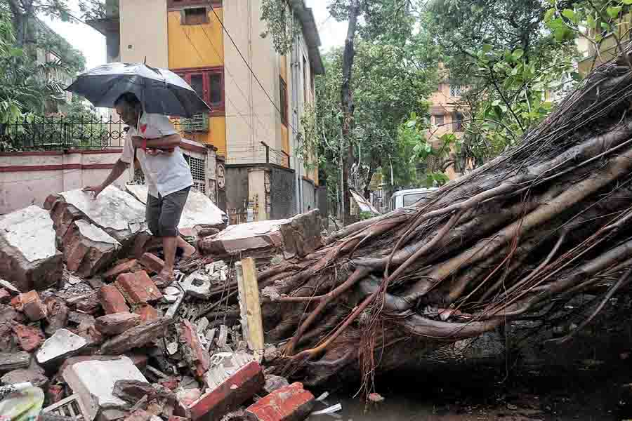
A huge peepal tree collapsed at Ballygunge Place on Sunday night, blocking traffic till Tuesday evening My Kolkata
“We have been largely saved but the unusual part was the long duration of the cyclone both on Sunday and large part of Monday,” said Sanjib Pradhan, a key member of Ghoramara panchayat, one of the most vulnerable islands of Sunderbans; a complain that was iterated by Sankar Ari of Bali island in Gosaba.
“Multiple factors worked in tandem to save the Sunderbans from greater disaster this time; firstly the landfall point of the cyclone that was slightly away from Indian border, secondly the midnight landfall meant that the cyclone impact peaked at a time when already the low tide started. Moreover the timing of the landfall, about three days after full moon meant that in any way the tide was at low ebb” explained Subhas Acharya, a member of Sunderbans Development Board, reminding that every time the luck would not be in favour of Indian Sunderbans.
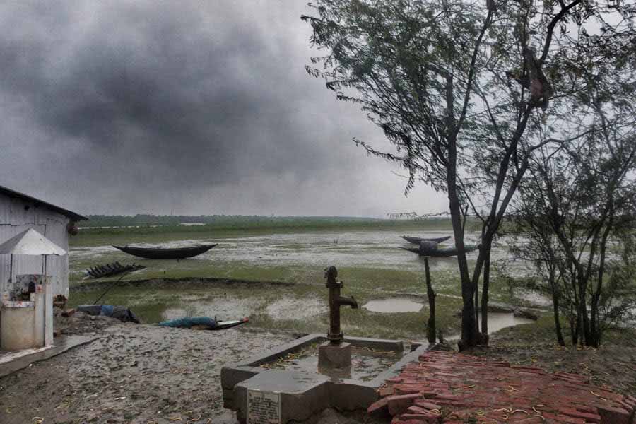
Impact of Cyclone Remal as seen in Canning, South 24-Parganas district, on Monday afternoon. Soumyajit Dey
“We need a comprehensive master plan and its prompt execution to ensure long-term sustainability of the Sunderbans. We have had several discussions but need the plan and its implementation at the earliest to save millions and the unparalleled biodiversity,” said Tuhin Ghosh, a professor of oceanography in Jadavpur University and a globally acknowledged Sunderbans expert.
A senior irrigation official agreed. “Yes, it’s a fact that multiple factors worked in favour of Indian Sunderbans during Remal. Just compare it with Aila; which, despite having similar wind speed, caused many times more damage in comparison as the landfall was in the Indian Sunderbans and overlapped with the high tide.