The prolonged heat-wave conditions in Kolkata and the rest of West Bengal are set to end with a rainy spell, the Met office said on Thursday.
“In south Bengal, including Kolkata, the showers are most likely on April 23 and 24,” said Sanjib Bandyopadhyay, deputy director-general of the India Meteorological Department, Kolkata.
The coastal districts of South 24-Parganas and Purba Medinipur might get some rain on April 22 as well. The hills, where the rain started on Wednesday, are likely to be wet till April 25.
In south Bengal, and a couple of districts of north Bengal, the heat-wave conditions are likely to last another 24 to 48 hours.
The Met office had issued a formal heat-wave alert for south Bengal on April 12.
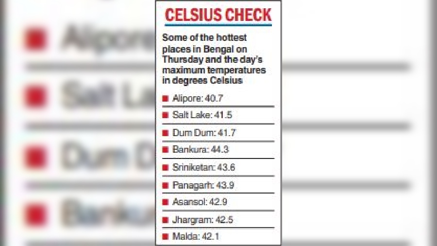
On Thursday, the Celsius inched towards the 41-degree mark in Kolkata. Many districts were even hotter (see chart).

The Met office recorded a maximum temperature of 40.7 degrees in Alipore. Salt Lake and Dum Dum sizzled at 41.5 and 41.7 degrees. Bankura continued to be the hottest district in Bengal, with a maximum temperature of 44.3 degrees.
Change-maker
An extratropical storm that originates in the Mediterranean region and often causes winter rain and snowfall in India is tipped to help tilt the weather scales in West Bengal.
“A Western Disturbance is passing through eastern India. Darjeeling got hailstorms under its effect on Wednesday. In the coming days, the system is likely to cause rain in south Bengal,” said a Met official.
A Western Disturbance reaches northwestern India via Iran, Afghanistan and Pakistan. It then keeps moving east through the upper reaches of the country, usually passing over Sikkim and Arunachal Pradesh.
“The system leads to the formation of a trough line that causes rain in Uttar Pradesh, Nepal, Sikkim, Bhutan and Arunachal Pradesh. But when the system is deep, the trough line descends enough to cause rain in Bihar, Jharkhand and West Bengal. This is what is likely in the coming days,” said the official.
Wind play
The dominance of dry northwesterly winds and the lack of moisture-laden southerly winds from the Bay are the two main factors behind the prolonged heat wave, according to Met officials.
Usually, dry northwesterly winds are active in West Bengal this time of the year, but not throughout the day. As evening approaches, moisture-laden southerly winds from the Bay start entering the coast. Strong southerlies often flow well beyond 100km from the coast.
The heating and the southerly winds together create ideal conditions for thunderstorms.
“But this time, the northwesterly winds are so strong that they are crossing the coast. The southerlies on the sea cannot make their way to the coast, leave alone more inland areas,” said Bandyopadhyay.

Vehicles parked under trees on the Maidan on Thursday afternoon, around the time the Celsius clocked 40.7 degrees in Alipore Picture by Gautam Bose
Lift needed
The mere presence of moisture is not enough for the formation of thunderclouds.
“There has to be a lifting mechanism. A cyclonic circulation or a trough of low pressure helps the moisture-laden winds to rise from the surface of the earth. The moist winds need a helping hand for around 5km from the earth’s surface. After that, they can rise on their own. But that initial helping hand is very crucial,” said a weather scientist.
The trough line that is expected to take shape in the coming days will serve that purpose, he said.
Not alone
The heat wave in West Bengal is not an isolated weather phenomenon. Southeast Asia is enduring an unprecedented heat wave, one that is being billed as the “worst-ever” recorded in April.
Several all-time high-temperature records have been broken, including a 113.7 degrees Fahrenheit (45.4 degrees Celsius) in Thailand last Friday, the nation’s hottest reading on record.
“Vast parts of Southeast Asia are going through an unusually hot spell. A high-pressure area on the Bay of Bengal is moving eastwards from the Indian coast, leading to a rise in temperature in Thailand, the Philippines and parts of China,” said a Met official.


