
Cyclone ‘Mocha’ is likely to form over the southeast Bay of Bengal in early May and the possibility of the West Bengal coast being affected is not ruled out, according to a forecast made by India Meteorological Department (IMD) on Tuesday.
As of now, IMD has predicted only the formation of a low- pressure area, but the circulation may turn into a severe cyclone in the second week of May. The system will be named as cyclone ‘Mocha’ if it intensifies into a cyclonic storm.
“A cyclonic circulation is likely to develop over southeast Bay of Bengal around May 6, 2023. Under its influence, a low pressure area is likely to form over the same region during subsequent 48 hours (May 7 and 8),” pointed out the IMD forecast under head ‘Tropical Weather Outlook’; a copy of which is with The Plurals.
Though the IMD is yet to spell out the possible route of the cyclonic circulation; experts are not ruling out the possibility of the West Bengal coast being affected; especially with most cyclones generated in the region now heading in that direction, according to a recent World Bank analysis.
Most recent cyclones in the region, from Amphan in 2020 to Asani in 2021 to Yaas in 2022, made landfall in the month of May.
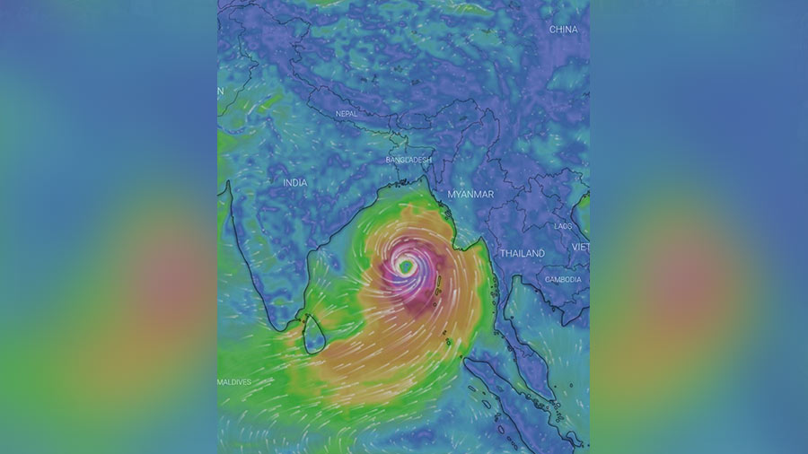
As of now, IMD has predicted only the formation of a low- pressure area, but the circulation may turn into a severe cyclone in the second week of May Source: Windy app
Most models are indicating initial northwestward movement of the cyclonic circulation with northeastward recurvature over central Bay of Bengal, indicating that Odisha and Bengal coasts as well as the Bangladesh coast may face the impact.
The issue was also discussed at Nabanna on Tuesday. “The issue of the possible cyclonic circulation was mentioned during the routine pre-monsoon meeting chaired by the chief secretary,” said Sanjib Banerjee, deputy director-general of IMD Kolkata.
Odisha chief minister also convened a preparatory meeting on Mocha on Tuesday, sources said.
The IMD report pointed out that the present conditions are conducive to the formation of cyclones in the Bay of Bengal; with both “tropical cyclone’s heat potential” and “sea surface temperature” over the entire Bay of Bengal reaching optimal values required for such formation.
“Yes, there is a possibility of a cyclonic circulation being generated by May 5 to 7; turning into a low-pressure subsequently and is expected to impact till May 11,” Mrutyunjay Mohapatra, director general of IMD, said on Tuesday afternoon.
“As of now a low-pressure belt is likely to form on May 8; but considering the fact that generally cyclones impact in May; a possibility always remains that the circulation may intensify,” said G.K. Das, head of IMD, Kolkata.
Several models have confirmed the development.
IMD-Global Forecast System (GFS) predicts that a low-pressure area over the southeast Bay of Bengal will intensify into a cyclonic storm on May 9 near the Andaman islands. It states that the storm will move north-northeastward towards the east-central Bay of Bengal till May 11, deviating from the Andaman islands.
The Global Ensemble Forecast System (GEFS), another weather model, predicts that a low-pressure area will be formed by May 7 followed by a depression.
The European Centre for Medium-Range Weather Forecast (ECMWF) suggests that a depression is likely to develop in the south Andaman Sea and the southeast Bay of Bengal followed by a cyclonic storm on May 11.
ECMWF, as well as another model, have predicted that a severe cyclonic storm may affect the region. A severe cyclone blows in the range of 89 to 118 km per hour wind speed.