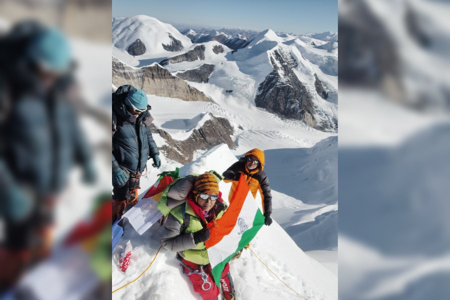
The MAK team, led by veteran mountaineer Basanta Singha Roy, has recently summited the technically challenging Gorichen peak in Arunachal Pradesh, marking a historic feat as the first-ever civilian team to achieve this accomplishment, according to the Indian Mountaineering Foundation. This achievement showcases the team’s mountaineering skills, perseverance and dedication to overcoming the formidable terrain. The team members were Basanta Singha Roy (leader), Rumpa Das, Prasanta Singha, Subrata Ghosh and Partha Sarathi Layek. Pemba Tshering (sherpa sardar), Mingma Tenzing Sherpa, Mingma Dorje Sherpa and Lila Raj Rai (cook) — all from Darjeeling — accompanied the team.
Summit dreams derailed
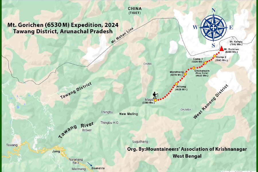
Mount Gorichen map and the climb route. While the IMF estimates the peak’s height at 6,530m, the MAK climbers’ GPS recorded it as 6,468m. (Sourced by The Telegraph)
The MAK team’s 2023 expedition to Gorichen had faced challenges that prevented its summit. While initial permissions from the Indian Mountaineering Foundation (IMF) were granted, detailed information on routes and logistics was scarce. Besides, the key guidance from experienced sources remained elusive due to “regional sensitivities”. Although it reached the base camp, locating Camp 1 proved difficult until the Indian Army offered GPS assistance. Unfortunately, one team member suffered high-altitude sickness and had to be evacuated, further weakened by another sherpa’s illness. At Camp 1, a vast crevasse halted progress toward Camp 2, forcing a base camp retreat. More so, an attempt to an alternative peak, Gorichen 6222, was similarly thwarted by logistical challenges.
Chilly October adventure begins
This time, the team decided to do it in October, though they knew the cold would be intense. The good old Pemba Tshering Sherpa, a trusted comrade, joined the team. Pemba Tshering climbed Gorichen in 2016 with an Arunachal government team, which included the renowned Anshu Jamsenpa. At that time, he was still new to mountaineering, under the guidance of his uncle, the famous Pemba Chhuti.
Gorichen is not a single peak but a mountain range with several summits — Gorichen Main, East, West and Gorichen 6222. It’s hard to tell which is the main peak, especially since maps only identify one of the summits as Gorichen. After consulting Anshu, an iconic mountaineer of Arunachal who knows this region like the back of his hand, Singha Roy learned that the peak Anshu climbed with Sherpa Tshering in 2016 was Gorichen Main, standing at 6,530m, according to the IMF. This assurance strengthened Singha Roy’s resolve for the climb.
The team started on October 8, including members approved by the IMF. On the morning of October 10, they arrived at Jang (40km before Tawang). From there, they stocked up on supplies and headed for the remaining 50km to Mago village.
The metal road that passes over the Mago Chu river was scenic. In 2016, this journey required trekking. Mago, known for its hot springs, posed some challenges last year regarding accommodation, but this time, a young boy offered the MAK team lodging in his home. The electricity ran from 4pm to the next morning. The road improved greatly compared to last year, so the team decided to stay there for two days. Mago sits at 11,500ft. The village’s head or gao bura was very helpful. The place lacks a mobile network, and the residents communicate via walkie-talkie, though a mobile tower, as the villagers say, will shortly be operational there. With the sparse population, the majority of the settlement is an army camp.
The road built by the army extends for another 5km up to Jithang. On October 12, the team began trekking with 12 horses carrying their supplies. The weather was favourable. Passing through Mago and across the Jithang Chu river, they trekked 11km to a scenic meadow by midday. Along the way, the team members met instructors and trainees from National Institute of Mountaineering and Adventure Sports (NIMAS). One of them, who had recently summited Gorichen Main on September 19, shared some information with Tshering.
Jithang is a large area — not suitable for farming but abundant in yak — though there are no sheep or goats. Here, two rivers — Sherje Chu and Thungthang Chu — meet, and the tree line ends just before reaching this place.
On October 13, the team reached Merathang, their second transit camp. The Thungthang Chu flowed far below.
On October 14, they arrived at Chokersam, their base camp, a large meadow with several streams flowing across the flat land. The team set up tents there, and the horses returned after delivering their gear. This marked the real beginning of the expedition.
Singha Roy said: “I felt confident about the route to Camp 1, especially since no other army expeditions were happening, meaning we were the only occupants here for a few days. The area, encircled by rocky mountains, was extremely cold, which made me somewhat anxious.”
On October 15, the weather was good, so the team set out for Camp 1 to ferry some of their loads, leaving Romit, Sushmita and Prosun at the base camp. The path to Camp 1 was challenging, mainly following the river and crossing boulders. Along the way, the mountaineers passed two glacial lakes. After a continuous climb of four-and-a-half hours, they reached Camp 1, where they covered the supplies with a tarpaulin and returned to base camp, exhausted after eight hours of trekking.
Accounts of risky final push
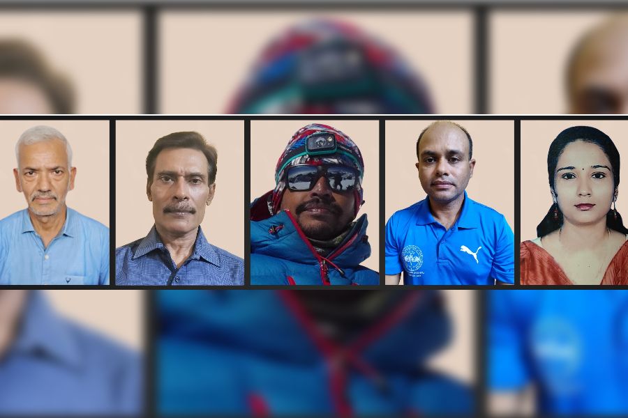
(Left to right) Basanta Singha Roy, Partha Sarathi Layek, Subrata Ghosh, Prasanta Singha and Rumpa Das. (Sourced by The Telegraph)
Prasanta Singha: We started towards Camp 2, crossing slate talus, boulders and a steep scree zone. We encountered an 80-degree rock wall slick with water, requiring fixed ropes and manoeuvring to avoid loose rocks. Nearing the glacier, we navigated around crevasses, climbing an increasingly steep ice slope using crampons and ice axes. The final ascent involved a four-hour push on a 70-degree slope, then a near-vertical, almost 90-degree icy wall where we climbed carefully to reach the summit. The narrow, razor-sharp ridge allowed space for just one or two to stand.
Rumpa Das: The climb from Camp 1 to Camp 2 was fully technical. We progressed northwest over boulders before reaching a steep rock wall, where fixed ropes and jumars were essential due to falling rocks and water flow. The route involved mixed snow and rock, leading to the ice wall, which we scaled using fixed ropes, navigating alongside crevasses and covering 400m to the Summit Camp. Starting at 1am, the summit team used crampons and ice axes on snow slopes, then tackled ice faces. After four intense hours, we reached a cornice where additional ropes were set for the final technical 50m stretch to the summit. Each climber tagged the peak and quickly descended to avoid overloading the unstable ropes.
Subrata Ghosh: The climb from Camp 1 to Camp 2 was technical, with steep, slippery rock walls and a constant risk of rockfall. Fixed ropes and jumars were essential on the challenging 80-degree east ridge toward the summit. The last 60m were particularly intense, with a nearly vertical ice wall requiring careful front-pointing on crampons. The narrow summit ridge had sheer drops on both sides, allowing only a brief moment for photos before a cautious descent.
Partha Sarathi Layek: We navigated a rockfall zone with boulders, quickly traversing the wall before ascending 200m using fixed ropes. After beginning our summit push, we faced a 70-degree wall of soft snow that steepened as we approached the summit. It required careful climbing near a cornice. The final ascent involved a wall of hard ice, marking the toughest part of the climb. At the summit, space was limited, forcing us to take turns for photos. The descent was perilous, especially near the cornice, and heavy snowfall made the boulders slippery, complicating our return to Camp 1, where we arrived drenched in snow.

