The low pressure area which originated from the Bay of Bengal moved to Gangetic West Bengal and Jharkhand resulting in heavy to very heavy rainfall in several districts of the state since Thursday night.
An associated cyclonic circulation extending up to 7.6 km above the mean sea level assisted in the rainfall activity.
Met statistics revealed that Latehar topped the rain chart during the last 24 hours with very heavy rainfall of 102 mm rain.
Hindgir in Hazaribagh district too recorded very heavy rain of 93 mm and so was Amarpara in Pakur district which recorded 92 mm of rain.
Chatra and Balumath in Latehar district recorded around 90 mm of rain while Mandar in Ranchi district recorded 85 mm of rain.
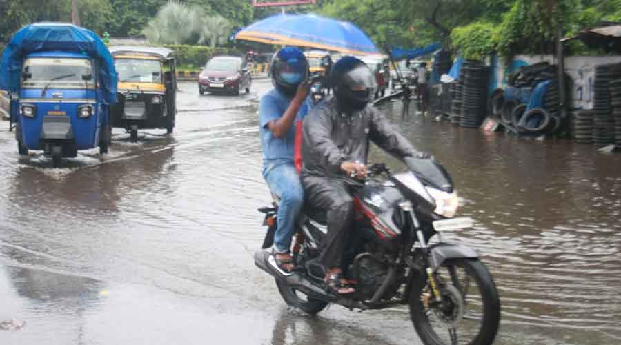
Vehicles negotiate through a waterlogged road at Sakchi in Jamshedpur on Friday . Bhola Prasad
Several places in Dhanbad district including Maithon and Panchet recorded around 78 mm of rain while Nandadih in Koderma district recorded 79 mm of rain.
Jamtara recorded 70 mm of rain while Lohardaga recorded 61 mm.
Jamshedpur and Ghatshila, both in East singhbhum district recorded around 60 mm of rain while Ramgarh and Ranchi experienced around 50 mm of rain.
Deoghar and Hazaribagh recorded around 45 mm of rain while Giridih and Pakur received around 30 mm of rain.
Dumka and Daltonganj recorded around 25 mm of rain. About 20 IMD observatories recorded rainfall between 10 mm and 15 mm since last evening due to the impact of the low pressure.
The sky remained overcast in most parts of the state on Friday with intermittent rains and winds blowing at an average speed of 20 Kmph.
"An active monsoon coupled with the low pressure resulted in heavy to very heavy rain over Jharkhand. The low pressure is likely to move north-westwards towards southern Bihar and Uttar Pradesh during the next two to three days," said Abhishek Anand, head of Ranchi Meteorological Centre.
The monsoon trough at mean sea level was on Friday passing through Ganganagar , Narnaul, Gaya and some parts of West Bengal and Jharkhand.
Today's satellite pictures indicated formation of a fresh low pressure area over southern parts of central Uttar Pradesh and an associated cyclonic circulation extending up to 7.6 km above mean sea level.
Weathermen said the impact of the low pressure that originated from the Bay of Bengal would gradually wane from tomorrow resulting in reduced rainfall activity.
However, weathermen said a few isolated places in north western and south western parts of the state were expected to witness heavy rain in the next 24 hours.
The heavy and widespread rain during the last 24 hours brought down the six per cent deficit rain to zero on Friday.
Rain data suggested that so far Jharkhand has received 513.7 mm of rain against a normal of 513 mm, resulting in zero deficit.