Researchers have said they had about 20 years ago warned of the risk of an “outburst” in the South Lhonak Lake that triggered Sikkim’s worst-ever flash flood on Wednesday, yet dam-building and unplanned construction continued along the Teesta’s downstream.
“Governments don’t take researchers and research papers seriously,” said Vimal Khawash, a professor at the Special Centre for the Study of North India, Jawaharlal Nehru University, Delhi.
“The debate must be on the dams and the unplanned urbanisation that is coming up instead of what (natural factors) triggered the flash flood.”
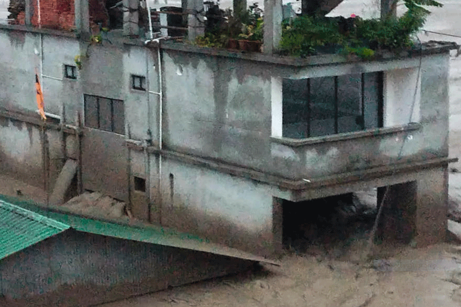
On Wednesday, the outburst from the lake caused the Teesta to swell to unprecedented levels, reports said. The floodwaters washed away the 1,200MW Sikkim Urja Teesta-Stage III Dam, 62km downstream from the lake, and destroyed at least 11 bridges in Sikkim.
Sikkim chief secretary V.B. Pathak said 19 people had died while 98 were missing till Thursday evening. More than 22,000 people have been affected in Sikkim alone.
Bengal government sources said 21 bodies had been recovered from the banks of the Teesta in Jalpaiguri and Cooch Behar till Thursday evening. It was not clear whether the Bengal body count included the Sikkim dead.
The first inventory of glacial lakes in the Sikkim Himalayas was made in 2003, with 266 lakes mapped and 14 of them identified as potentially critical. Similar studies were conducted in 2013 and 2017, and researchers repeated their warnings.
“Strikingly, in all these studies, South Lhonak Lake was identified as potentially dangerous with a high outburst (sudden release of water) probability,” said Ashim Sattar, scientist, Divecha Centre for Climate Change, IISc, Bangalore.
Sattar, who does modular computing too, published two papers — the latest in 2021 being a study of six avalanche scenarios leading to glacial lake outburst floods (GLOFs).
GLOFs occur when lakes formed by melting glaciers burst open as they are unable to hold the entire volume of water. Most researchers have contended that the Teesta tragedy was caused by a GLOF.
“We studied the South Lhonak Lake because the threats were well published and in the news for a long time,” Sattar told The Telegraph.
The South Lhonak Lake was identified as the fastest-growing lake in Sikkim, with its glacier receding by 2km between 1962 and 2008 and by another 400 metres between 2008 and 2019.
A researcher explained the link between the lake and the Teesta, the most prominent river in the region.
“Water from the various lakes drain into the Teesta, which trickles from the Tso Lhamu Lake in north Sikkim. Water from the South Lhonak Lake first drains into the Goma channel, which then joins the River Zemu, 36km downstream of the lake,” the researcher said.
The researcher added: “The Zemu further joins the River Lachen at Hema, about 40km downstream, which then joins the Teesta at Chungthang. The volume of the Teesta increases at Chungthang.”
Despite the warning from researchers, the 1,200MW hydel project was commissioned in February 2017, which resulted in the erection of one of the biggest dams in the region.
Policymakers’ keenness to use Sikkim’s water resources – particularly following the success of the Chukha hydel project in Bhutan – had prompted them to draw up plans to set up 27 hydel projects in the state with an installed capacity of 5,248MW.
“Because of protests in some areas only 9 have been commissioned so far, while work on 15 projects is going on in the Teesta basin,” a researcher said. “The construction of the dams is resulting in other construction activities around them.”
Many researchers maintain that while dams are a source of clean energy, the projects must be sanctioned after taking into consideration factors such as the geology and geomorphology of the place.
An academic said that governments were increasingly deciding to start projects on the assumption that the environment impact assessment (EIA) would be favourable towards them.
Many urban planners admitted that downstream towns had not come up in a planned manner in the last 40-odd years.
The major habitations along the Teesta basin include Chungthang, Lachung, Mangan, Dikchu, Singtam, Rango and Melli in Sikkim as well as Teesta Bazar, Sevoke, Jalpaiguri and other places in north Bengal.
“The importance of the Teesta, which completely changed its course from being a tributary of the Ganga to that of the Brahmaputra, is of immense socio-economic importance to the entire region as it also flows through northwest Bangladesh,” Khawash said.