The rain has fallen for what feels like two years straight: in drizzles, in showers and, with troubling regularity, in downpours. The weather has always been Britain’s favorite topic of conversation. The clouds are familiar. Increasingly, though, they are also a threat.
In September, a month’s rain fell in a single day in some parts of England. The 18 months to March 2024 were England’s wettest in recorded history. Even on an island that has built at least part of its identity around tolerating inclement weather, it has been impossible to ignore the deluge. Flooding has submerged fields, ruined homes, and at times, cut off whole villages.
As sea levels rise and extreme weather becomes more common, experts say that Britain’s traditional defenses — sea walls, tidal barriers and sandbanks — will be insufficient to meet the threat. It is not alone: In September, deadly floods in Central Europe led to the deaths of at least 23 people.
But on a tendril of land curling out from the coast of Somerset, in southwestern England, a team of scientists, engineers and conservationists has embraced a radical solution.
In a project costing 20 million pounds (around $26 million), tidal waters were allowed to flood the Steart Peninsula in 2014 for the first time in centuries.
Rather than attempting to resist the sea, the land was given back to it. It was, in the words of Alys Laver, the conservationist who oversees the site, a “giant science experiment.”
A decade on, its results might offer a blueprint for how some parts of Britain — and the rest of the world — might adapt to the reality of climate change.
A ‘Ridiculous Scheme’
When Laver first visited the peninsula just over 10 years ago, it looked like a “moonscape,” she recalls. Acres of farmland, used as pasture for dairy and beef farming, were being churned up by bulldozers and excavators. Fences, hedges and ditches were being leveled. Almost half a million cubic meters of soil was being removed.
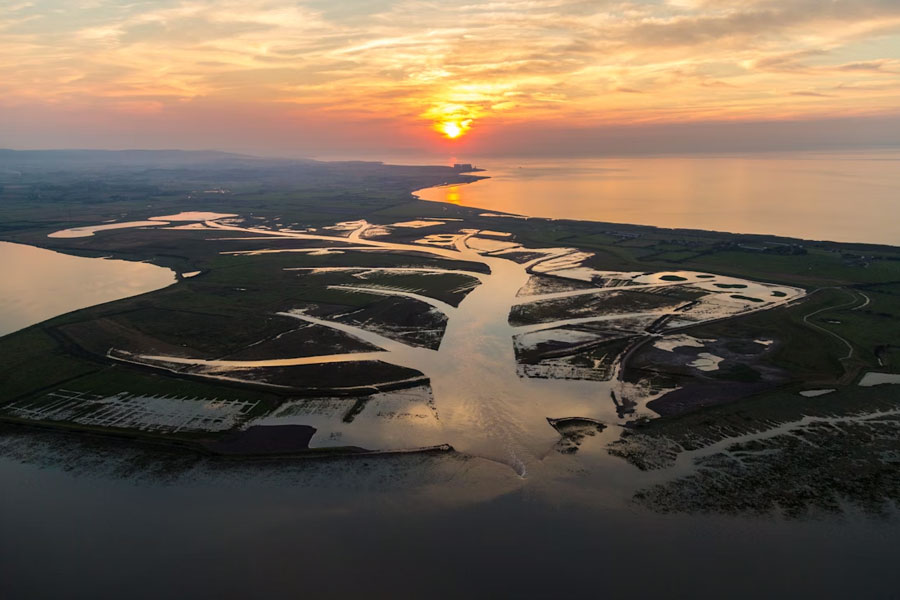
A new creek system was dug out, snaking inward from the River Parrett, whose waters flow into the Bristol Channel and out into the Atlantic Ocean.
Laver was there on behalf of her employer, the Wildfowl and Wetlands Trust, a charity that shaped the project alongside the Environment Agency, the government body responsible for protecting England’s land and coastline. The idea was to turn what had been farmland into salt marsh, an ancient ecosystem that soaks up water as the tide comes in and releases it as the sea retreats.
It was not a universally popular plan. Farmers were paid around 5,000 pounds an acre to give up their land. “Not everyone was in favor,” said one local farmer, Andy Darch. “I thought it might bring opportunities. But there were plenty who wanted the traditional defenses to be strengthened. They felt that the government was staging a managed withdrawal from the sea defenses.”
One displaced farmer, Robert Pocock, told a local newspaper that the plan was “environmental vandalism.” Ian Liddell-Grainger, the area’s then-Conservative Party lawmaker, denounced it in Parliament as “an extravagant, ridiculous scheme.” Describing flooding in Somerset as “an almost annual crisis,” he accused the Environment Agency of believing “the levels should be allowed to return to the swampy wilderness that they were in the Middle Ages.”
That was actually sort of true. Salt marsh, which is created by the deposits of fine mud and silt left behind by retreating seawater, has been around for thousands of years. It was used for salt making and for grazing animals in the Roman period.
Over the centuries, marshland was increasingly viewed as unproductive. Thousands of acres were drained and turned into arable land or developed for housing and industry. Since 1860, Britain has lost 85% of its salt marshes, according to the U.K. Center for Ecology and Hydrology, a research institute.
Returning Steart to swampy wilderness was, in part, an acknowledgment that the overdevelopment of coastal land had made flooding more likely, not less.
And so, as the sun rose on Sept. 8, 2014, the tide was allowed to flood the peninsula. Water flowed through a new gap, about 220 yards wide, and then into channels and rivulets that, from above, looked like the veins of a leaf. The land had been surrendered. The experiment had begun.
Selling Mud
The thing with marshland, Laver acknowledged with a rueful shake of the head, is that it is not romantic. Objectively, it is wet mud. And wet mud is not the sort of thing that excites people.
Still, on an overcast day earlier this year, as we strolled through a world at least partly of her creation, she could not keep the wonder from her voice. Beneath the tranquil veneer of the marsh, pocked with pools and streams, there was a remarkable sense of activity. “It solves so many problems,” Laver said.
The marsh acts as a natural and hugely effective bulwark against flooding, absorbing and slowing tides before they can encroach inland. Even last winter — the wettest anyone in the area could remember — the village at one edge of the peninsula did not flood. Paths through the marsh remained passable. A steep bank, covered with grass and significantly higher than the old flood wall, now borders the river.
The area is also a haven for wildlife. Bird-watching blinds with giant windows offer glimpses of godwits, plovers, oystercatchers, egrets and herons. A growing population of avocets — black-and-white wading birds with distinctive, curling beaks — has gathered around the pools of brackish water.
And the marsh has, over time, become a source of pride to the local population. Darch, who spent much of his career as a poultry farmer, started grazing cattle there in 2019, at the invitation of the Wildfowl and Wetlands Trust.
It is not without complications: This year, Darch found himself watching the sky nervously, wondering when the weather would be dry enough to move his cattle back onto their pastures. If the ground is too damp, he explained, it might create health problems in the cows’ hoofs. “They like to have nice dry feet,” he said.
But the rewards are plentiful. On the marsh, the cattle are not corralled by fences; instead, their movements are governed by digital collars, which play music to discourage them from drifting into certain areas. Their diets are varied and organic, meaning they provide high-quality, free-range meat.
The meat’s traceable origin strengthens the bond between farmers and consumers, Darch said. Often, he noted, “there is a disconnect there, between our food and where it comes from.” He and two colleagues set up a company, Blue Carbon Farming, in an attempt to bridge that divide.
The cows provide other benefits, too. “Cows are natural eco-engineers,” Darch said. “They eat the grass but don’t take it right down, as sheep would. That means the grass grows longer, which provides more cover for wildlife.”
The cows like some grasses more than others; not unlike children, they sometimes have to be encouraged to eat certain greens. Even those they ignore, though, are trampled, allowing other strains to flourish and catering to a more abundant array of wildlife.
The alliance between the conservationists and the local population has helped to overcome initial objections to the project. Laver now oversees a small army of volunteers who help maintain the marsh — trimming hedges, clearing paths. So many want to help that there is a waiting list.
There is, though, another benefit to the project at Steart. The beauty of this wet mud, after all, is not in how it looks, but what it does.
A Carbon Sponge
The most obvious effect of the salt marsh at Steart is in how it counteracts some of the consequences of climate change: absorbing the increasing volume of water that pours from the sky and swells from the banks of the River Parrett.
But it also helps address the underlying cause.
As they planned the project at Steart, Laver and her colleagues knew that salt marsh trapped carbon. It does this in two ways. The plants that thrive in salt marsh grow quickly, drawing carbon from the atmosphere. And the soils in the marshes are largely anaerobic, meaning they break down carbon in the sediment left behind by retreating tidal waters very slowly — over hundreds, or thousands, of years.
What was not certain was how effective the marsh might be at trapping carbon.
The data that has emerged, a decade in, is encouraging. “We’ve been as high as 19 tons of carbon per hectare, per year,” Laver said. That figure is meaningless to most, but she is used to explaining it: “It’s the equivalent to charging 15 trillion phones” every year, she said, or “heating 33,000 homes.”
That achievement comes with two caveats. One: Laver knows the marsh will not continue to capture carbon at such a prodigious rate. And two: even that high-water mark represents a fraction of Britain’s total emissions.
“We have done studies on all of the natural marshes in Britain, and they capture somewhere in the region of 46,500 tons of carbon a year,” said Craig Smeaton, a lecturer in geography at the University of St. Andrews. “Britain’s carbon footprint is about 58 million tons each year.”
Smeaton is an ardent supporter of both conserving the country’s remaining salt marsh and reclaiming that which has been lost, but he cautioned that using carbon capture as the primary rationale would be unwise.
“It is absolutely sensible to be creating more salt marsh in Britain, but the primary benefits are for flood defenses and for wildlife,” he said. “Carbon sequestration should be seen as a secondary or tertiary benefit.”
The impact may be more meaningful elsewhere. In North America and in Australia, in particular, the marsh is almost “like peat,” Smeaton said, and therefore traps carbon at a far greater rate. “They can draw down crazy amounts,” he said. “And mangrove is a thousand times better.”
Perhaps that is why there has been such international interest in the experiment at Steart. Laver has given talks in Canada and in South Korea. The site has even hosted delegations from the Netherlands, a place that knows a thing or two about holding back the sea.
Steart is often described as a “rewilding” project, but Laver prefers not to use that term. The terrain has been returned to nature but it has been engineered by human ingenuity and curated by human hands.
“Looking after the site requires a lot of intervention,” Laver said, sheltering from a brief, furious rain squall in a bird blind. Through a window, we surveyed a landscape that was still, but ever-changing; natural, but human-made; new, but as it once was.
The New York Times News Service