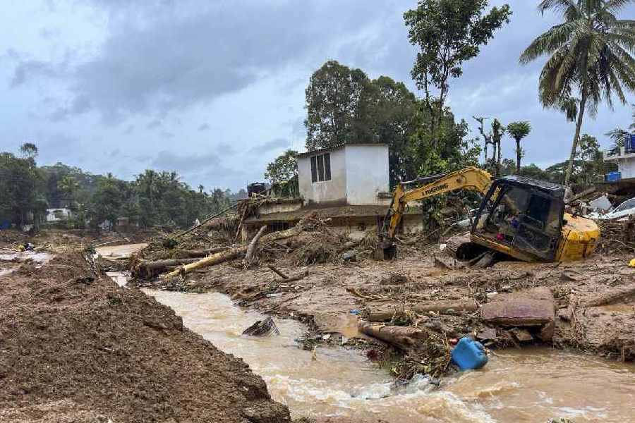
Rain forecasts, dozens of automated weather stations and a statewide landslide and flood vulnerability map couldn’t avert the human toll from rain-triggered landslides in Wayanad on Tuesday because of critical gaps in information required to protect populations, experts have said.
Geologists studying Kerala’s vulnerability to landslides have said localised early warning systems and maps showing the most likely routes for the flow of landslide debris could have helped lower the human toll had the facilities for such critical inputs been in place.
Scientists have known for over two decades that landslides are a major hazard along segments of the Western Ghats mountain chain that run through nearly 47 per cent of the state. A scientific review in 2009 had determined that nearly all of Kerala’s 14 districts are prone to landslides, with Wayanad and Kozhikode susceptible to what geologists call “deep landslides” in which the sliding surface is typically well below the depth of tree roots.
Destabilisation of hill slopes from deforestation, terracing, and cultivation of crops incapable of root cohesion — a process that mechanically stabilises a slope and lowers the risk of a landslide — have accelerated the processes leading to landslides, the review had said.
Under these circumstances, landslides have “become more destructive given the increasing vulnerability of population and property”, the review, co-authored by Sekhar L. Kuriakose, currently member-secretary of the Kerala State Disaster Management Authority, and others had said.
The Kerala State Disaster Management Authority was the first in the country to release a landslide and flood susceptibility map of Kerala in geoinformation file formats for the public.
But geologists say such a map alone isn’t sufficient to protect people which requires localised early warning systems. “What we require is real-time analysis of how much rain has fallen or is about to fall over specific landslide-susceptible soil zones,” said K.S. Sajin Kumar, assistant professor of geology at the University of Kerala, Thiruvananthapuram. “If such information is available to authorities in real-time, they could identify areas at high risk of imminent landslides.”
Alongside such early warning systems, Sajin Kumar said moving people out of harm’s way would require advance knowledge of both where a landslide is imminent and what specific routes mud, rocks, and other debris from the landslide will take as they roll downhill.
“This can be determined through modelling local terrain and geological information to generate landslide route maps,” Sajin Kumar said. Both, early warning systems and the land route maps, will require enhanced investments in disaster preparedness, he added.
Kuriakose, in a February 2019 paper presented at a symposium on landslides in Kerala, had also flagged another issue — the collection and access to disaster risk information, including hydro-meteorological data, is limited and scattered across multiple agencies.