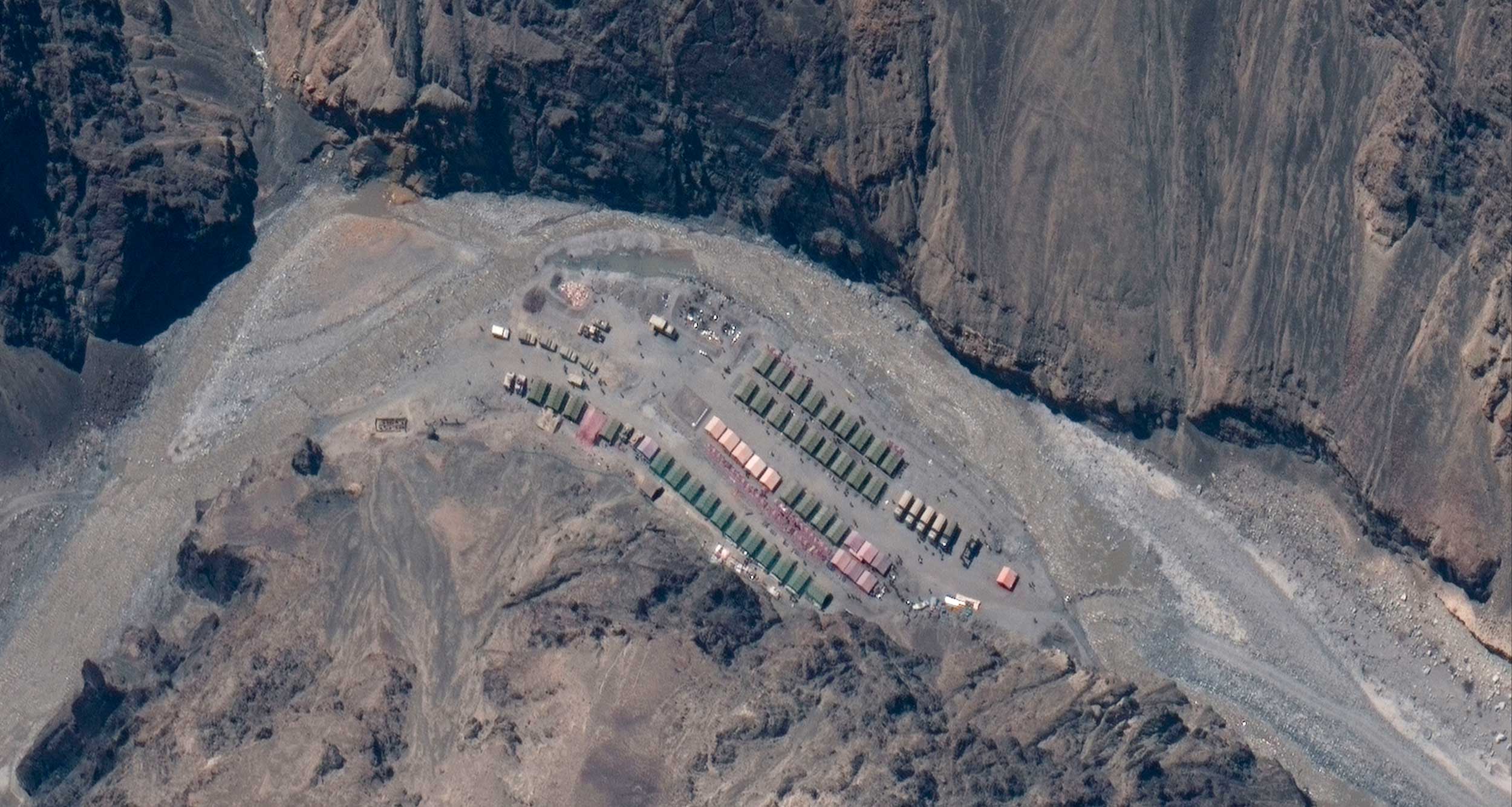
Satellite images that emerged on Wednesday suggested a fresh Chinese build-up in the Galwan Valley, a site of the 1962 war that was kept out of the dispute list until two months ago.
A red line added by the Twitter handle that posted the images to denote the Line of Actual Control (LAC) showed the structures on the Indian side. The LAC is undefined, making it difficult to pinpoint the side on which a precise point falls, but a military veteran said the structures appeared to be “1.5km into the Indian side”.
The Indian Army did not comment officially. Off the record, army sources said the camps in the images showed structures “on the Chinese side”.
However, the just two-day-old satellite images and a report by a news agency preferred by the Narendra Modi government strengthened a perception that China was reinforcing its presence in the area. The disclosures came on a day the army chief, General M.M. Naravane, visited forward areas in eastern Ladakh and reviewed the operational situation.
⦾ The satellite images, dated June 22, were put out by Twitter handle @detresfa on Wednesday. The @detresfa Twitter handle has been releasing satellite images since the border tensions began in early May.
The Twitter handle tweeted: “Images via @Maxar of the #GalwanValley face-off point on 22 June 2020 show possible defensive positions being set up by #China, small walls, trench type areas have now appeared on site #IndiaChinaFaceOff”. Maxar is a US space technology company.
⦾ Quoting sources, the news agency ANI reported that “in the Galwan river area, where the violent face-off took place between the two armies resulting in a high number of deaths on both sides, the Chinese have built some of their structures after the clash”.
“An observation post-like structure of the Chinese removed by the Indian army troops on June 15-16 night has also come up again near the Patrolling Point 14,” it added. PP-14 is the site where the carnage took place on June 15.
Brigadier (retd) M.P.S. Bajwa, who had commanded the brigade that captured Tiger Hill in the Kargil War, tweeted: “Updates — Ladakh Area. China adamant to take control of Galwan Valley & trying to fortify PP-14 area along Galwan River. China also reported to move troops in areas of Depsang to provide depth to Karakuram pass and dominate Our Road — Darbuk-Shoyok-Daulat Beg Oldie (DBO).”
He added: “Chinese have refused to withdraw from Finger-4 in Pangong Tso lake area, an intrusion of almost 8km from Finger-8 area, which is a LAC as per our perception. Chinese build-up seen with armourer/mech (mechanised) & artillery in East of areas of Gogra in Hot Springs area.”
Another veteran, Colonel (retd) Ajai Shukla, tweeted about the satellite images: “Large Chinese camp in Galwan Valley, 1.5km into Indian side of the Line of Actual Control (LAC), shown as the red line. There is no Indian camp in the Galwan Valley, after India agreed on June 6 to de-militarise the valley to where the Galwan joins the Shyok.”
There have been suggestions that after May 5, when the first scuffle this summer was reported, the Chinese had expanded their “claim line” into Indian territory.
An Indian Army source said off the record: “At the corps commander talks on Monday, a decision was taken to de-escalate in a phased manner, including in areas close to the LAC. We are hopeful. The timing of the disengagement is still being decided.”