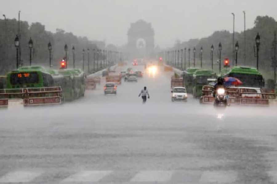
Delhi recorded 153 mm of rain in 24 hours ending 8:30 on Sunday, the highest in a single day in July since 1982, the India Meteorological Department said.
An interaction between a western disturbance and monsoonal winds is leading to an intense rainfall spell over northwest India, including Delhi which experienced the season's first "very heavy" rainfall.
The Safdarjung Observatory, the city's primary weather station, recorded 153 mm of rainfall in 24 hours ending 8:30 am on Sunday, the highest since the 24-hour rainfall of 169.9 mm on July 25, 1982, a senior IMD official said.
It was the third-highest single-day rainfall for July since 1958, it added.
The city logged 133.4 mm of rain on July 10, 2003, 126 mm on July 28, 2009, and 125.7 mm on July 8, 1993. The all-time high of 266.2 mm on July 21, 1958.
Delhi has recorded eight "very heavy" rain events (between 115.6 mm and 204.4 mm) in July since 1969, the IMD data shows.
The Met Office has issued a yellow alert, warning of moderate rain which could cause more problems to the residents of Delhi.
The weather stations at Ridge, Lodhi Road and Delhi University recorded 134.5 mm, 123.4 mm, and 118 mm of precipitation, respectively.
According to the Met Office, rainfall below 15 mm is considered "light", 15 mm to 64.5 mm is "moderate", 64.5 mm to 115.5 mm is "heavy", and 115.6 mm to 204.4 mm is "very heavy".
Any amount exceeding 204.4 mm is classified as "extremely heavy" rainfall.
The heavy rain submerged parks, underpasses, markets and even hospital premises, and caused chaos on the roads.
Pictures and videos of commuters wading through knee-deep water flooded social media platforms, raising concerns about the efficiency of the city's drainage infrastructure.
Strong winds and showers also caused disruptions in power and internet connectivity in several areas.
With the showers bringing back the familiar scenes of waterlogged roads and long lines of vehicles stuck in the deluge, residents expressed anguish over Delhi's "poor drainage system".
Delhi has three major drainage basins: Najafgarh, Barapullah, and Trans-Yamuna.
During rainfall, stormwater on the eastern side of the central ridge directly flows into the Yamuna. On the western side, smaller drains merge into the Najafgarh drain, which eventually empties into the river.
The eastern region of Delhi is low-lying and was originally part of the Yamuna floodplain. The existing stormwater drainage system in Delhi is prone to congestion, primarily caused by waste and sewage, leading to sluggish water flow.
Different parts of Delhi experience annual flooding due to factors such as excessive concrete structures, the disappearance of water bodies, encroachments on the stormwater drains, and the discharge of untreated sewage and waste.
The management of the drainage system involves multiple agencies, further complicating the situation, according to the city government's state action plan for climate change.
The last drainage master plan for Delhi was created in 1976 when the city's population was approximately 6 million.
The government had asked IIT Delhi to prepare a new 'Drainage Master Plan for NCT of Delhi'. The institute submitted a final report in 2018 but a technical panel of the city government rejected it, citing "discrepancies in data".
Earlier this year, the government tasked the Public Welfare Department, which manages the largest part (2,064 km out of a total of 3,741 km) of the storm run-off system in Delhi, to prepare a new plan.
According to officials, Delhi's outdated drainage system can handle only up to 50 mm of rainfall in 24 hours.
In April, the PWD had identified 165 waterlogging spots and five hotspots -- New Rohtak Road, under the Zakira Nagar flyover, the Loni Road roundabout, near the Jahangirpuri Metro Station, and the Karala Kanjhawala Road. PWD’s central control room also monitors serious water logging areas through 24-hour CCTV surveillance.
The state action plan for climate change identifies "heat waves and heavy precipitation events on fewer number of days" as two major vulnerability pain points.
The IMD issued a warning of isolated extremely heavy rain in Himachal Pradesh and Uttarakhand throughout Sunday.
Heavy to very heavy rain is predicted in isolated areas of Jammu and Kashmir until Monday, and in eastern Rajasthan, Haryana, Chandigarh, Delhi, and Punjab on Sunday.
The IMD said heavy rainfall is unlikely in the region starting from July 11.
Delhi recorded above-normal rainfall in the last four months -- 53.2 mm against a normal of 17.4 mm in March, 20.1 mm against an average of 16.3 mm in April, 111 mm against a normal of 30.7 mm in May and 101.7 mm against a normal of 74.1 mm in June.
The city has gauged 164 mm of rainfall in July so far. On average, the city receives 209.7 mm of rainfall in the entire month.
Meteorologists attributed the above-normal rainfall to higher-than-usual western disturbances -- weather systems that originate in the Mediterranean region and bring unseasonal rainfall to northwest India -- this year.
Amid bountiful rains, the Safdarjung Observatory did not record any heat wave day in the summer season (April to June) this year for the first time since 2011.
The IMD has predicted normal rainfall (94 to 106 per cent of the long-period average of 280.4 mm) in the country in July.
However, it anticipates below-normal precipitation over many areas of northwest, northeast and southeast peninsular India.
Except for the headline, this story has not been edited by The Telegraph Online staff and has been published from a syndicated feed.


