A previously unknown earthquake 2,500 years ago abruptly altered the course of the Ganga, rerouting its main channel in present-day Bangladesh and leaving behind a muddy floodplain currently used for rice cultivation.
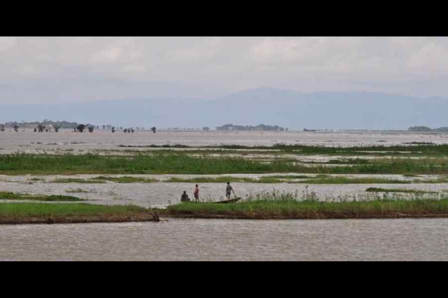
Scientists announced on Monday their discovery of a 1km-to-1.7km-wide meandering paleochannel, 45km south of the modern Ganga-Padma river's main channel. The paleochannel is a scar left by the river’s earlier course before the earthquake, they said.
The paleochannel, detected via satellite imagery, and features called sand dikes in the mud — signatures of an earthquake-triggered process called liquefaction — point to a magnitude 7 or 8 earthquake that originated more than 180km away, the researchers said.
“In a delta region, rivers move over decades to centuries — that is not unusual,” Elizabeth Chamberlain, a geologist at Wageningen University in the Netherlands and the Ganga study’s first author, told The Telegraph in a telephone interview. “But this was an abrupt, big geological event,” she added.
The study’s findings, published on Monday in the science journal Nature Communications, provide fresh evidence of the vulnerability of the Ganga-Brahmaputra delta region across Bangladesh and eastern India to even moderate earthquakes.
“Geological records show that large earthquakes have ravaged Bangladesh and the neighbouring region several times in the historic and prehistoric past,” said Syed Humayun Akhter, a former geology professor at Dhaka University, now the vice-chancellor of Bangladesh Open University and the study’s co-author.
The earthquakes have left signatures such as the sand dikes, changes in terrain features and what geologists call river avulsions, the rapid abandonment of a river channel and the emergence of a new one.
Scientists have documented over 100 river avulsions through history, including those by the Mississippi in the US, the Yellow River in China, and the Kosi in India.
“Most avulsions are naturally occurring shifts in rivers. This is the first avulsion of a very large river tied to an earthquake,” said Michael Steckler, a geophysicist at the Columbia Climate School in the US and a study team member.
“The (Ganga) river shifted from flowing to the southeast along a pathway parallel but south of the current Ganges-Padma rivers to flowing down the Bhagirathi-Hooghly channel,” Steckler told this newspaper via email.
The earthquake had caused the Ganga’s main channel to shift westward to a north-south flow. However, under the influence of changes in land elevation, the river has moved since the earthquake into its current modern channel.
Sometime between 1550 and 1650, the river changed course and moved eastwards, and joined the modern lower Meghna channel. "These later avulsions occurred over decades and were not triggered by earthquakes," Steckler said.
The researchers say the earthquake 2,500 years ago may have been caused either by the slip of the oceanic crust under the continental plate below Bangladesh, Myanmar and northeastern India, or by the slip of the Indian plate beneath the Asian plate in the Himalayan region.
An earlier 2016 study by Akhter and US collaborators found that these zones were building stress that could produce earthquakes comparable to the one 2,500 years ago. A high-intensity earthquake in 1762 had generated a tsunami that moved up the river and hit Dhaka.
The Ganga-Brahmaputra delta landscape sits atop a large pile of mud layers — sediments ferried by the rivers downstream from the Himalayas into the delta — as deep as 30km thick. The mud is vulnerable to liquefaction, a process in which water-saturated mud layers behave like a liquid.
“The potential for large-magnitude earthquakes in the nearby Himalaya and Burmese fronts… is high,” Akhter said.
“The effects of strong shaking from such an earthquake would affect much of the country, including the densely populated Dhaka. Large earthquakes occur less frequently than serious floods but they can affect much larger areas and can have long-lasting economic, social and political effects,” he said.
It is unclear how the Ganga’s abrupt change in course 2,500 years ago may have impacted local communities, said Chamberlain, who specialises in research on how rivers change course and impact local communities.
“We can presume that the event would have led to some shift in populations, emergence of new settlements -- archaeological work may provide the answer,” Chamberlain said.